Canada’s Instrumentation Leader Since 1946.

Canada’s Instrumentation Leader Since 1946.
 Hoskin Environmental
Sampling and monitoring instruments for air, water, weather and soil for the environmental, agricultural, mining and research markets.

 Hoskin Geotechnical
Materials and Product testing for soil, asphalt, petroleum, concrete, mining, cement, and research industries.

 Hoskin Instrumentation
Sensors, transducers and instrumentation for industry, manufacturing, research and development and factory automation.
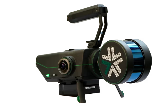
Nexys: The Most Advanced Autonomous Navigation
 Contact us for details
Nexys transforms 3D mapping with its modular design and advanced technology, promising efficiency, safety, and precision in challenging environments. Combining proprietary autonomy algorithms and SLAM-based LiDAR scanning, Nexys achieves survey-grade results without constant piloting, even in GPS-denied or hazardous areas. Its versatility shines through quick configuration changes, from handheld to aerial setups, all meeting rugged IP67 standards. Nexys ensures fast data capture with up to 1.9 million scan points per second and 5mm @ 1 sigma accuracy, while real-time visualization and colorization allow on-site verification before leaving. Certified to withstand tough conditions, Nexys adapts effortlessly, indoors or outdoors.
Map Accuracy: ±5 mm
Points Per Second: ~2,000,000
Megapixels: 3.2 MP
Horizontal field of view: 360°
When it comes to capturing data, Nexys doesn’t disappoint. The SLAM-based spatial mapping technology ensures fast, accurate, and consistent results. With up to 1.9 million scan points per second and survey-grade accuracy of up to 5mm @ 1 sigma, you can trust Nexys to deliver precise data, every time.
Nexys is built for versatility. Using Drone Link, Nexys can be mounted onto any integrated robotic platform to rapidly map with survey-grade accuracy. Quickly switch between various configurations — handheld, backpack, aerial robot, terrestrial robot, vehicle, pole, or custom setups. And thanks to its rugged design meeting IP67 standards, Nexys can handle any mapping environment.
Explore new frontiers with ExynAero DJ34, the ultimate autonomous drone for high-risk environments. From mining to construction, experience the future of aerial exploration firsthand. With advanced autonomy features, including beyond-visual-line-of-sight (BVLOS) flight capabilities and real-time obstacle avoidance, the DJ34 drone ensures safety while navigating complex environments. Equipped with gimballed Velodyne LiDAR and a 4K camera with built-in lighting, it delivers high-resolution 3D maps and video footage for comprehensive insights.
20+ Minute Flight Time
Thanks to Exyn’s advanced planning algorithms, ExynAero drones boast an impressive flight time of over 20 minutes. This efficiency means robots can cover more ground in less time, providing customers with extensive data collection opportunities and minimizing downtime.
Modular Design
Exyn’s modular design, powered by the Nexys system, allows for seamless transition between autonomous and manual mapping. The ExynAero DJ34 can navigate hazardous environments autonomously, and then detach its payload for manual mapping, resulting in comprehensive 3D models.
Precise Data Visualization
ExynAero drones provide precise data visualization, generating detailed maps overlaid with real-time sensor data. These comprehensive 3D visuals offer actionable insights, empowering users to make informed decisions based on accurate information.
Smart Collision Avoidance
Safety is paramount, which is why ExynAero drones are equipped with advanced collision avoidance technology. With an onboard SLAM engine, ExynAero drones can adapt to changing surroundings, detect and avoid obstacles in real-time, and navigate through challenging situations, such as avoiding thin wires or people.
We understand the importance of getting it right the first time. That’s why Nexys allows you to capture and process data on-site, giving you real-time visualization with full detail and colorization. With Nexys, you can ensure your scans are accurate and complete before you leave the site, minimizing the need for rework.
| SYSTEM | |
|---|---|
| Durability | Built to IP-67 standards |
| Weight (incl. battery) | 3.1kg |
| Weight (w/o battery) | 2.4kg |
| Size (H x W x L) | 104 mm x 180 mm x 361 mm |
| Operating Temperature | -20° to 45° C |
| Platform modularity | Drone/vehicle/backpack-mount, handheld |
| CAPABILITIES | |
| GPS-Required | No (GPS-optional) |
| Low/No-Light Operation | ✓ |
| Drone Autonomy | License Purchased Separately |
| Ground Autonomy | License Purchased Separately |
| GIMBALLED LIDAR | |
| Laser Safety Class | 1 |
| Field Of View | 360° horizontal |
| Rotation Frequency | 10 Hz |
| Gimbal Rotation | ~1Hz |
| Max Range | 300 m @ 80% Surface Reflectance |
| Points Per Second | ~2,000,000 |
| Return Type | Triple with Intensity |
| OUTPUT | |
| Real-Time Data Visualization | ✓ |
| Data Collection Replay | ✓ |
| Point Cloud Colorization | ✓ |
| Point Cloud | XYZ, RGB, Intensity |
| Point Cloud Formats | LAS, PLY, XYZ |
| Other Outputs | Trajectory |
| Map Accuracy | ±5 mm |
| RGB CAMERAS | |
| Model | FLIR Blackfly |
| Field of View | 220o |
| # of Cameras | 2 |
| Megapixels | 3.2MP |
| CONTROL UNIT | |
| CPU | Intel Core i7 |
| RAM | 64GB DDR4 |
| Storage | 512GB internal SSD |
| Interfaces | USB 3.0, WiFi |
| POWER | |
| DC Input | 12-48 V |
| Power | 75 W |
| BATTERY* | |
| Batteries Included | 2 |
| Nominal Voltage | 14.8V |
| Battery Standard | V-Mount |
| Battery Capacity (each) | 98 Wh |
| Battery Chemistry Type | Li-Ion |
| Typical Operating Time | ~2 hours |
| TABLET | |
| Model | Dell Latitude 7230 12’, IP-65 |
| Interface | Capacitive Touchscreen |
| Operating System | Ubuntu 22.04 |
| Software Interface | ExynViewTM, mission control & live data streams |
| Communication | 2.4GHz & 5.8GHz WiFi WPA2 encryption |
| Weight | 1.3kg |
| CASE | |
| External Size (H x W x L) | 28 x 41 x 53.4 cm |
| Shipping Weight | 20.5 kg |
| ACCESSORIES* | |
| Hand-carry Mount | ✓ |
| Industrial Vehicle Mount | ✓ |
| Drone Mount | Purchased Separately |
| BackPak Case + Mount | Purchased Separately |
| Protective Cage | Purchased Separately |
| GPS-receiver | Purchased Separately |


Copyright - 2026 - Hoskin Scientific

