Canada’s Instrumentation Leader Since 1946.

Canada’s Instrumentation Leader Since 1946.

 Hoskin Environmental
Sampling and monitoring instruments for air, water, weather and soil for the environmental, agricultural, mining and research markets.

 Hoskin Geotechnical
Materials and Product testing for soil, asphalt, petroleum, concrete, mining, cement, and research industries.

 Hoskin Instrumentation
Sensors, transducers and instrumentation for industry, manufacturing, research and development and factory automation.
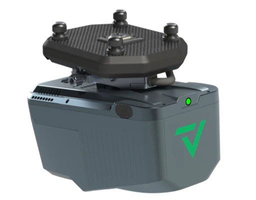
Developed through the collaboration of GeoCue and CHC Navigation, the TrueView 540 delivers engineering-grade LiDAR performance at a cost-effective price point. Combining dense point cloud generation, precise laser scanning, and flexible software options, the TrueView 540 is redefining what’s possible in accessible geospatial mapping.
 Contact us for details
Developed through the collaboration of GeoCue and CHC Navigation, the TrueView 540 delivers engineering-grade LiDAR performance at a cost-effective price point. Combining dense point cloud generation, precise laser scanning, and flexible software options, the TrueView 540 is redefining what’s possible in accessible geospatial mapping.
| Scanner Precision | Returns | Operation Temperature | Camera Sensor |
| 5 mm | Up to 8 | -20° to 50° C |
45MP |
The TrueView 540 combines advanced LiDAR and high-resolution imagery for comprehensive data collection. At its core is a CHCNAV single-beam laser scanner operating at a 1535 nm wavelength, capable of capturing up to 8 returns per pulse. With a maximum usable LiDAR range of 400 meters for targets with greater than 20% reflectivity and a pulse repetition rate of up to 500 kHz, the system delivers dense, high-quality point clouds ideal for demanding geospatial applications.
| Feature | Details |
|---|---|
| Data Collection | LiDAR + Imagery |
| Laser Scanner | CHCNAV single beam laser scanner – 1535 nm wavelength |
| LiDAR Beams / Returns | Up to 8 |
| Usable Range | 400 m for targets with > 20% reflectivity |
| Positioning and Orientation System | CHC |
| Pulse Repetition Rate | Up to 500 kHz |
| Scanner Precision | 5 mm |
| Scanner Accuracy | 15 mm |
| GNSS/INS Position Accuracy | 10-20 mm |
| GNSS/INS Angle Accuracy | Angle: 0.006° Roll/Pitch, 0.019° Heading |
| System Accuracy | The TV540 incorporates CHC’s PPK navigation solution combined with the scanner’s 5 mm repeated ranging accuracy, the system achieves exceptional absolute accuracy from 2 to 5 cm. |
| System Operation Temperature Range | -20° to 50° C |
| Camera Sensor | 45 MP Global Shutter Full frame Camera |
| Mass | 1.9 Kg for the payload only 2.15 Kg with accessories |
Each TrueView 540 package comes with everything needed to begin high-quality 3D data collection and processing:
• TrueView 540 LiDAR/Camera Payload
• GNSS Antenna
• Battery and Charger
• USB Thumb Drive
• Rugged Sensor Hardcase
• LP360 Drone Software (with Strip Align and Photo Add-Ons)
• 1-Year Hardware and Software Support
It integrates seamlessly with major drone platforms such as:
DJI. Inspired Flight, Skyfront. Freefly, Wispr, Harris Aerial, XER
TrueView 3D imaging Sensors are designed and manufactured in our Huntsville, Alabama, USA facilities.


Copyright - 2026 - Hoskin Scientific

